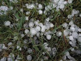
CALGARY, Alta. – Residents across Southern Alberta are keeping a close eye on the sky today, as the region faces a renewed risk of severe thunderstorms just one day after a powerful Alberta hail storm left a trail of damage.
Storms that developed late Sunday afternoon off the southern foothills brought torrential rain and large, damaging hail to “Canada’s hail alley,” flooding streets and battering crops. The stormy pattern is set to continue through Monday evening.
(H2) ‘Tennis Ball-Sized’ Hail Pelts Southern Alberta Sunday
The severe weather on Sunday, July 27th, lived up to the region’s reputation. A particularly intense, severe-warned storm south of Pincher Creek and west of Cardston reportedly produced hail as large as tennis balls.
Social media was quickly flooded with images from across the area showing streets turned white, looking more like winter roads than summer lanes due to the thick accumulation of hail. Photos also revealed significant damage, including shredded leaves on trees and battered agricultural fields, a major blow to farmers in the region. The heavy rainfall accompanying the hail led to localized flooding, making travel difficult for drivers.
(H2) Renewed Storm Risk for Monday, July 28
The threat is far from over. According to weather models, another round of storms began firing up west of Calgary early Monday morning and is tracking eastward throughout the day.
Forecasters anticipate that another series of storms will develop off the foothills late this afternoon. These storms are expected to intensify as they move into the evening and overnight hours, with the primary risk area stretching south of Calgary.
Communities in the path of these potential storms include:
- Claresholm
- Lethbridge
- Medicine Hat
Residents in these areas should be prepared for another round of heavy rain and large hail. The primary hazards remain localized flooding and potential damage to crops, trees, and property.
Albertans are strongly encouraged to monitor local weather alerts and watch the radar for any incoming severe weather systems.

